


(C) 2012 Reginald P. Webster. This is an open access article distributed under the terms of the Creative Commons Attribution License 3.0 (CC-BY), which permits unrestricted use, distribution, and reproduction in any medium, provided the original author and source are credited.
For reference, use of the paginated PDF or printed version of this article is recommended.
Thirty-eight species of Aleocharinae are newly reported from New Brunswick, bringing the total number of species known from the province to 216. Thirty-one of these species are newly recorded for the Maritime provinces, and four of them, Phloeopora oregona Casey, Gyrophaena michigana Seevers, Gyrophaena wisconsinica Seevers, and Tomoglossa decora (Casey), are newly recorded for Canada. Tomoglossa constitutes a new generic record for Canada. Collection and habitat data for all these species are presented and discussed. Color habitus, median lobe of the aedeagus, and male tergite and sternite 8 images are presented for the first time for Phloeopora oregona, and references to illustrations are provided for all other species included in this paper. A color habitus image is presented for Tomoglossa decora.
Staphylinidae, Aleocharinae, new records, Canada, New Brunswick
The Aleocharinae is the largest subfamily of Staphylinidae with over 400 species in 92 genera recorded from Canada (
The following records are based in part on specimens collected as part of a general survey by the first author to document the Coleoptera fauna of New Brunswick.
Collection methodsVarious methods were employed to collect the specimens reported in this study. Details are outlined in
Most specimens were dissected to confirm their identity. The genital structures were dehydrated in absolute alcohol and mounted in Canada balsam on celluloid microslides and pinned with the specimens from which they originated.
DistributionDistribution maps, created using ArcMap and ArcGIS, are presented for each species in New Brunswick. Every species is cited with current Distribution in Canada and Alaska, using abbreviations for the state, provinces, and territories. New provincial records are indicated in bold under Distribution in Canada and Alaska. The following abbreviations are used in the text:
| AK | Alaska | MB | Manitoba |
| YT | Yukon Territory | ON | Ontario |
| NT | Northwest Territories | QC | Quebec |
| NU | Nunavut | NB | New Brunswick |
| BC | British Columbia | PE | Prince Edward Island |
| AB | Alberta | NS | Nova Scotia |
| SK | Saskatchewan | NF & LB | Newfoundland and Labrador* |
* Newfoundland and Labrador are each treated separately under the current Distribution in Canada and Alaska.
Acronyms of collections examined and referred to in this study are as follows:
AFC Atlantic Forestry Centre, Natural Resources Canada, Canadian Forest Service, Fredericton, New Brunswick, Canada
CNC Canadian National Collection of Insects, Arachnids and Nematodes, Agriculture and Agri-Food Canada, Ottawa, Ontario, Canada
LFC Laurentian Forestry Centre, Natural Resources Canada, Canadian Forest Service, Ste. Foy, Quebec, Canada
NBM New Brunswick Museum, Saint John, New Brunswick, Canada
RWC Reginald P. Webster Collection, Charters Settlement, New Brunswick, Canada
Results Species accountsAll records below are species newly recorded for New Brunswick, Canada. Species with ** are newly recorded from the Maritime provinces; species with *** are newly recorded for Canada.
Family Staphylinidae Latreille, 1806Subfamily Aleocharinae Fleming, 1821
Tribe Aleocharini Fleming, 1821
http://species-id.net/wiki/Aleochara_rubripennis
Map 1; illustrations inNew Brunswick, Queens Co., Cranberry Lake P.N.A. (Protected Natural Area), 46.1125°N, 65.6075°W, 21–27. V.2009, R. Webster & M.-A. Giguère, mature red oak forest, Lindgren funnel trap (1 ♀, RWC). York Co., Keswick River at Rt. 105, 45.9938°N, 66.8344°W, 3.VI.2008, R. P. Webster, silver maple swamp, in entrance to woodchuck burrow (1 ♀, RWC).

Collection localities in New Brunswick, Canada of Aleochara rubripennis.
This species was reported from groundhog (Marmota sp.) and ground squirrel (Cittellus sp.) burrows, usually early in the spring (
MB, ON, QC, NB (
http://species-id.net/wiki/Gnathusa_minutissima
Map 2; illustrations inNew Brunswick, Sunbury Co., Acadia Research Forest, 45.9799°N, 66.3394°W, 18.VI.2007, R. P. Webster coll., mature red spruce and red maple forest, sifting leaf litter (1 ♀, 1 ♂, RWC, LFC); same locality data and collector except 14.V.2007, sifting moss near brook (1 ♀, 1 ♂, RWC, LFC).

Collection localities in New Brunswick, Canada of Gnathusa minutissima.
In New Brunswick, adults were found in leaf litter and moss near a brook in a mature red spruce (Picea rubens Sarg.) and red maple (Acer rubrum L.) forest. In Newfoundland, adults were collected in pitfall traps in an old balsam fir (Abies balsamea (L.) Mill.) forest in June and July (
. NF, NB (
http://species-id.net/wiki/Oxypoda_orbicollis
Map 3; illustrations inNew Brunswick, Restigouche Co., Mount Atkinson, 447 m elev., 47.8192°N, 68.2618°W, 21.VII.2010, R. P. Webster, boreal forest, small shaded spring-fed brook with mossy margin, sifting saturated moss (1 ♀, RWC).

Collection localities in New Brunswick, Canada of Oxypoda orbicollis.
In eastern Canada, adults were found in balsam fir forests and maple forests and were collected in pitfall traps, Luminoc pitfall traps, and Lindgren funnel traps or sifted from forest litter and sphagnum (
YT, AB, ON, QC, NB, NS, LB (
New Brunswick, York Co., Charters Settlement, 45.8340°N, 66.7450°W, 14.V.2004, R. P. Webster coll., mixed forest, in wood pile under bark of spruce (1 ♂, 1 sex undetermined, RWC); same data except 45.8188°N, 66.7460°W, 16.IV.2005, R. P. Webster coll., clearcut, under bark of white pine log (1 ♂, LFC); same locality data and collector except 45.8286°N, 66.7365°W, 3.VI.2007, 6.VI.2007, mature red spruce and red maple forest, under scolytid infested bark of red spruce (1 ♂, 2 ♀, 1 sex undetermined, RWC); 15 km W of Tracy, off Rt. 645, 45.6848°N, 66.8821°W, 26.IV–0.V.2010, R. Webster & C. MacKay, coll., old red pine forest, Lindgren funnel trap (1 ♀, RWC).
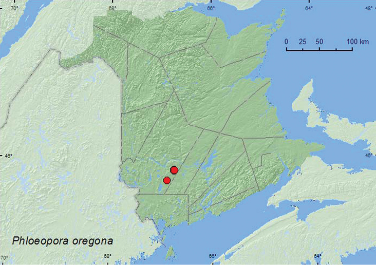
Collection localities in New Brunswick, Canada of Phloeopora oregona.
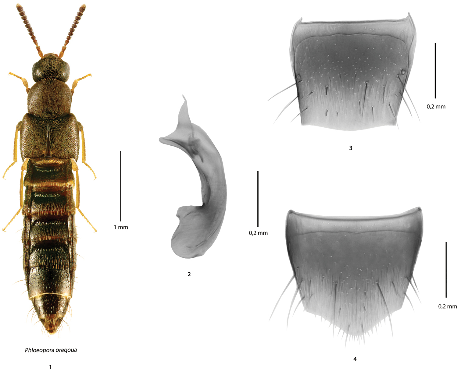
Phloeopora oregona Casey (based on male specimens from NB): 1 habitus in dorsal view 2 median lobe of the aedeagus in lateral view 3 tergite 8 and 4 sternite 8.
In New Brunswick, adults were found in a mixed forest, a mature red spruce (Picea rubens Sarg.) and red maple forest, and in an old red pine (Pinus resinosa Ait.) forest. Specimens were taken from under bark of spruce and white pine (Pinus strobus L.), and under bark of red spruce infested with Scolytinae. One individual was captured in a Lindgren funnel trap. Specimens were collected during April, May, and June.
NB (new Canadian record).This specieswas, until now, only known from the type locality (The Dalles) in Oregon (
Author JK examinedthetype material ofthe following species: Phloeopora arctica Lohse, Phloeopora corticalis (Gravenhorst), Phloeopora ferruginea Casey, Phloeopora liberta Casey, Phloeopora oregona Casey, Phloeopora sublaevis Casey, Phloeopora scriba Eppelsheim, and Phloeopora testacea (Mannerheim). All species of this genus are similar externally to each other and differ in small details such as body proportions (e.g., width of pronotum, length of elytra), density of punctation and pubescence on forebody, body color, and shape of the apical part of median lobe of aedeagus in lateral view. The shape of the median lobe of aedeagus in specimens from New Brunswick is similar to that of Palaearctic Phloeopora corticalis and Nearctic Phloeopora oregona, but externally is more similar to Phloeopora oregona and Phloeopora testacea, which have dense pronotal punctation and pubescence, and are less glossy than Phloeopora corticalis. The median lobe of aedeagus is strongly produced ventrally at apex in Phloeopora corticalis and Phloeopora oregona and less so in the other species. We tentatively affiliate the New Brunswick specimens with Phloeopora oregona and suspect that this species is transcontinental in distribution in North America.
http://species-id.net/wiki/Brachyusa_helenae
Map 5; illustrations inNew Brunswick, Carleton Co., Jackson’s Falls, 46.2257°N, 67.7437°W, 12.IX.2009, R. P. Webster coll., river margin near waterfall, splashing moss near splash zone of waterfall (10 ♂, 8 ♀, RWC, LFC); Gloucester Co., Bathurst, Daly Point Reserve, 27.VII.2009, R. P. Webster, sea beach, in seepage area (fresh water) (1 ♀, LFC). Madawaska Co., Third Lake, 47.7786°N, 68.3783°W, 21.VI.2010, R. P. Webster, partially shaded brook, gravel/clay margin, under alders (splashing & turning gravel) (1 ♂, LFC); Gagné Brook at First Lake Rd., 47.6077°N, 68.2534°W, 23.VI.2010, M. Turgeon & R. P. Webster, northern hardwood forest, shaded brook, among gravel on gravel bars, splashing & turning gravel (1 ♂, LFC). Restigouche Co., Jacquet River Gorge P.N.A., 47.8256°N, 66.0770°W, 13.VIII.2010, R. P. Webster, large shaded brook among cobblestones (1, sex undetermined, NBM); same locality and collector except 47.7765°N, 66.1277°W, 13.VIII.2010, Jacquet River, among moss on rocks in middle of river, collected by splashing rocks (1 ♀, RWC); Wild Goose Lake, 420 m elev., 47.8540°N, 68.3219°W, 7.VI.2011, R. P. Webster & M. Turgeon, lake margin with emergent Carex & grasses, treading Carex & grasses (1 sex undetermined, LFC). York Co., Keswick River at Rt. 105, 45.9938°N, 66.8344°W, 3.VI.2008, R.P. Webster coll., upper river margin, in flood debris on sand/clay mix (2 ♀, RWC); Keswick River at Rt. 105, 45.9920°N, 66.8334°W, 9.VII.2009, silver maple swamp, margin of vernal pond, splashing (1 ♀, NBM); Charters Settlement, 45.8391°N, 66.7345°W, 25.IV.2010, R. P. Webster, beaver dam, in debris near outflow from dam (1 sex undetermined, LFC).
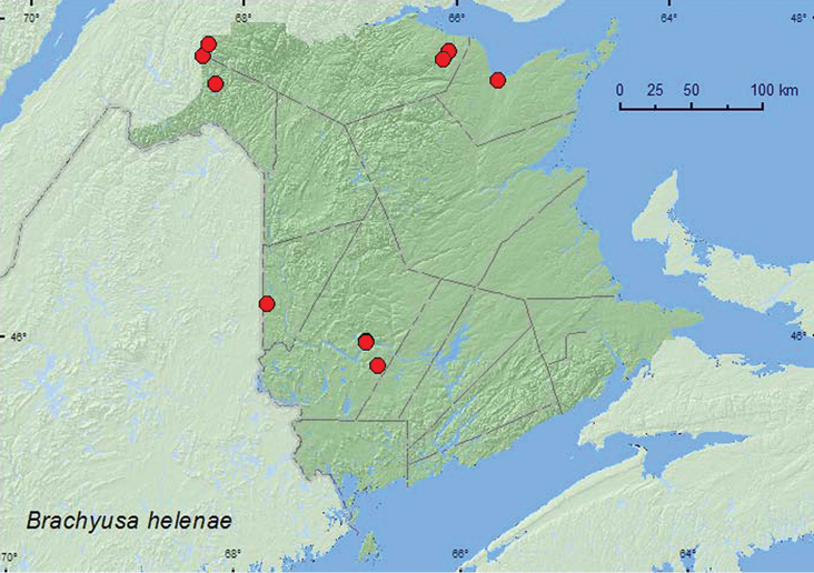
Collection localities in New Brunswick, Canada of Brachyusa helenae.
In New Brunswick, most adults of Brachyusa helenae were found near flowing water. Many specimens were collected frommoss near the splash zone of a waterfall. It took 5–10 min. before adults appeared after repeated splashing. Other individuals were collected from moss on rocks in the middle of a river, from gravel on a gravel bar along a shaded brook, from gravel on a gravel/clay margin of a partially shaded brook, from among cobblestones along a large shaded brook, and in flood debris resting on a sand/clay mix along an upper river margin. Most individuals from these habitats were collected by splashing water on moss and gravel, or turning gravel. A few specimens were collected by treading emergent Carex and grasses on the margin of a lake near the outflow of a stream and by splashing water on debris on the margin of a vernal pond in a silver maple (Acer saccharinum L.) swamp near a river. One individual was sifted from debris on a beaver (Castor canadensis Kuhl) dam near the outflow area (flowing water) from the dam. Adults from New Brunswick were collected during April, June, July, August, and September. In Labrador, adults were captured in July and August on sand and gravel on the banks of the Churchill River (
AK, NT, NB, LB, NF (
http://species-id.net/wiki/Gnypeta_atrolucens
Map 6; illustrations inNew Brunswick, Albert Co., Caledonia Gorge P.N.A., at Crooked Creek, 45.7930°N, 64.7764°W, 1.VII.2011, R. P. Webster, small clear cold rocky river, in moss on rocks on river margin (1 ♂, 1 ♀, NBM). Carleton Co. Jackson Falls, 46.2257°N, 67.7437°W, 12.IX.2009, R. P. Webster, river margin near waterfall, splashing moss near splash zone of waterfall (2 ♂, 1 ♀, RWC). Madawaska Co., at Green River, 47.6918°N, 68.3202°W, 21.VI.2010, M. Turgeon & R. Webster, river margin, among gravel on gravel bar (1 ♀, RWC). Restigouche Co., Kedgwick Forks, 47.9085°N, 67.9057°W, 22.VI.2010, R. P. Webster, on exposed rocks in middle of river (1 ♂, NBM); Jacquet River Gorge P.N.A., 47.7765°N, 66.1277°W, 13.VIII.2010, R. P. Webster, Jacquet River, among moss on rocks in middle of river, collected by splashing rocks (2 ♂, 2 ♀, NBM, RWC); same locality and collector but 47.8208°N, 66.0088°W, 14.VIII.2010, shaded brook, in moss on rock in middle of brook (1 ♂, NBM).
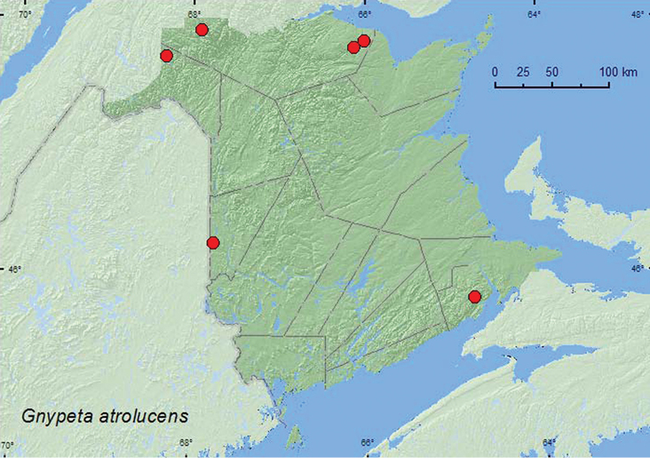
Collection localities in New Brunswick, Canada of Gnypeta atrolucens.
In New Brunswick, Gnypeta atrolucens was typically found in riparian habitats. Adults were collected by splashing water on moss near the splash zone of a waterfall, splashing water on moss and rocks in the middle of a river and a brook, and splashing water on exposed rocks in the middle of a river. At the latter site, adults emerged from cracks in the rocks after splashing. It generally took up to 10 min. and repeated splashing before adults appeared on the moss or rocks. One individual was collected from gravel on a gravel bar on a river margin. Elsewhere, adults were collected during July and August at altitudes from 61–853 m, otherwise little was previously known about the habitat associations of this species (
QC, NB, NF, LB (
http://species-id.net/wiki/Tachyusa_americanoides
Map 7; illustrations inNew Brunswick, Carleton Co., Wakefield, Bell Forest Nature Preserve, 46.2152°N, 67.7190°W, 12.VII.2004, K. Bredin, J. Edsall & R. Webster, coll., river margin, under debris (1 sex undetermined, RWC). Sunbury Co., Maugerville, Portebello Creek N.W.A. (National Wildlife Area), 45.8992°N, 66.4248°W, 24.VI.2004, R., P. Webster coll., silver maple forest, margin of slow river under litter on muddy soil (1 sex undetermined, 1 ♀, LFC, RWC). York Co., Douglas, Keswick River at Rt. 105, 45.9943°N, 66.8337°W, 18.VI.2004, R. P. Webster, coll., silver maple forest, under debris on muddy soil near small pool (2 sex undetermined, LFC, RWC); Charters Settlement, 45.8456°N, 66.7267°W, 16.V.2010, 10.VI.2010, R. P. Webster, coll., beaver dam, among grassy debris near an overflow area of dam, near flowing water (2 ♂, 1 ♀, RWC); same locality and collector but 45.8331°N, 66.7279°W, 20.V.2010, beaver dam, among sticks, debris and clay on dam (1 ♂, RWC).
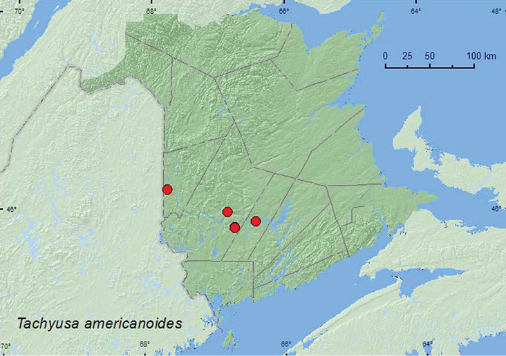
Collection localities in New Brunswick, Canada of Tachyusa americanoides.
In New Brunswick, Tachyusa americanoides was collected from grassy debris near the overflow area of a beaver dam, from among sticks, debris, and clay on a beaver dam, from debris on muddy soil along a slow-flowing river in a silver maple swamp, from debris along the margin of a rocky river, and from debris on muddy soil near a small pool in a silver maple forest. Adults were collected during May, June, and July.
NT, BC, AB, MB, ON, NB, NS, NL (
http://species-id.net/wiki/Tachyusa_obsoleta
Map 8; illustrations inNew Brunswick, Queens Co., Welsford (Bayard) near Nerepis River, 45.4441°N, 66.3300°W, 27.VI.2006, R. P. Webster, coll., river margin, among grass and debris near water (3 ♀, RWC); Bayard at Nerepis river, 45.4426°N, 66.3280°W, 25.V.2008, 30.V.2008, 20.VI.2008, R. P. Webster, coll., river margin, lightly splashing fine sand (3 ♂, 3 ♀, LFC, RWC). York Co., Douglas, Keswick River at Rt. 105, 45.9922°N, 66.8326°W, 9.V.2006, R. P. Webster, river margin, on moist clay (1 ♀, RWC).

Collection localities in New Brunswick, Canada of Tachyusa obsoleta.
In New Brunswick, most adults of Tachyusa obsoleta were collected during May and June by lightly splashing water on fine sand near a river margin. Other individuals were found on moist clay and by sifting grass and debris along river margins.
BC, SK, NB (
http://species-id.net/wiki/Gyrophaena_nana
Map 9; illustrations inNew Brunswick, York Co., NE of Exit 271 off Hwy 2, 45.8776°N, 66.8254°W, 8.VI.2008, Stephen Clayden, coll., mixed forest, in mushroom on log (1 ♂, RWC).

Collection localities in New Brunswick, Canada of Gyrophaena nana.
The specimen from New Brunswick was collected from a mushroom in a mixed forest during June.
YT, AK, BC, AB, MB, ON, NB, NF (
http://species-id.net/wiki/Gyrophaena_neonana
Map 10; illustrations inNew Brunswick, Carleton Co., Jackson Falls, 46.2200°N, 67.7230°W, 12.IX.2008, R. P. Webster, hardwood forest, in fleshy polypore mushroom on beech log (1 ♂, RWC).
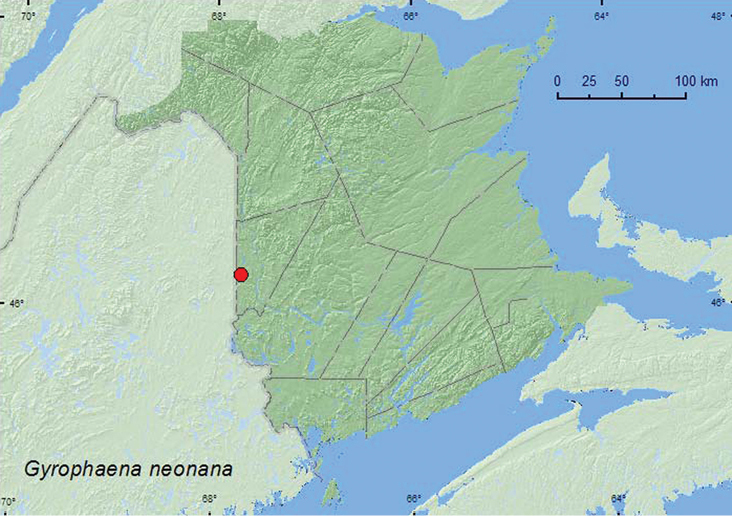
Collection localities in New Brunswick, Canada of Gyrophaena neonana.
The sole specimen from New Brunswick was collected from a fleshy polypore mushroom on an American beech (Fagus grandifolia Ehrh.) log during September. Little is known about the bionomics of this species.
YT, NB, NF (
http://species-id.net/wiki/Gyrophaena_caseyi
Map 11; illustrationsNew Brunswick, Carleton Co., Meduxnekeag Valley Nature Preserve, 46.1910°N, 67.6740°W, 13.VIII.2006, R. P. Webster, mixed forest, on Pleurotus sp. on side of log (1 ♂, RWC); near Belleville, 1.3 km E jct. Rt. 540 & Plymouth Rd., 46.1880°N, 67.6848°W, 20.IX.2008, R. P. Webster, hardwood forest, in small gilled mushrooms on log (2 ♂, 4 ♀, RWC, 2 ♂, LFC). Restigouche Co., Jacquet River Gorge P. N. A., 47.8201°N, 65.9992°W, 12.VIII.2010, R. P. Webster, black spruce/balsam fir/cedar forest near Belledune Bog, in gilled mushroom (1 ♂, RWC).

Collection localities in New Brunswick, Canada of Gyrophaena caseyi.
In New Brunswick, adults of Gyrophaena caseyi were collected during August and September from fresh gilled mushrooms and Pleurotus sp. on the side of a log. This species was found in a hardwood forest, a mixed forest, and a black spruce (Picea mariana (Mill.) B.S.P.), balsam fir, and eastern white cedar (Thuja occidentalis L.) forest.
. QC, NB (
Gyrophaena caseyi and Gyrophaena nanoides Seevers are very similar to each other externally and have similar genitalia. These two species were confused by
http://species-id.net/wiki/Gyrophaena_nanoides
Map 12; illustrationsNew Brunswick, Carleton Co., (Belleville) Meduxnekeag Valley Nature Preserve, 46.1980°N, 67.6854°W, 31.VIII.2006, R. P. Webster, mixed forest, on gilled mushroom(1 ♂, 2 ♀, NBM, RWC); same locality and collector but 46.1907°N, 67.6740°W, 7.IX.2004, mixed forest, on fleshy (gilled) fungi (1 ♂, 1 ♀, NBM); same locality and collector but 46.1897°N, 67.6710°W, 12.IX.2008, mixed forest, on gilled mushroom, (GYR-RW-8, 1 ♂, LFC); near Belleville, 1.3 km E jct. Rt. 540 & Plymouth Rd., 46.1860°N, 67.6847°W, 20.IX.2008, R. P. Webster, mixed forest with hemlock, on small gilled mushrooms on rotten log (GYR-RW-22, 1 ♂, LFC; GYR-RW-23, 1 ♂, NBM, GYR-RW-24, 1 ♂, NBM; GYR-RW-25, 1 ♂, NBM ); same locality data and collector but 20.IX.2008, on Pleurotus sp. on log (GYR-RW-61, 1 ♂, NBM); Jackson Falls, “Bell Forest”, 46.2200°N, 67.7230°W, 12.IX.2008, R. P. Webster, hardwood forest, on gilled mushroom on log (GYR-RW-36, 1 ♂, NBM; GYR-RW-37, 1 ♂, NBM; GYR-RW-35, 1 ♀, NBM; GYR-RW-27, 1 sex undetermined, NBM). Queens Co., Cranberry Lake P.N.A., 46.1125°N, 65.6075°W, 2.IX.2009, R. P. Webster, red oak forest, in small stalked polypore fungus on forest floor (1 ♂, RWC); same locality data, forest type, and collector, 22.IX.2009, in Boletus sp. (2 ♂, RWC). Restigouche Co., Jacquet River Gorge P.N.A., 47.8201°N, 65.9992°W, 12.VIII.2010, R. P. Webster, black spruce/balsam fir/cedar forest near Belledune Bog, in gilled mushroom (1 ♂, RWC); same locality and collector but 47.7883°N, 65.9819°W, 17.VIII.2010, black spruce forest, mossy forest floor, in Russula mushroom (2 ♂, NBM, RWC). Saint John Co., Chance Harbour, 45.1391°N, 66.3696°W, 24.VIII.2006, R. P. Webster, red spruce and birch forest, on gilled mushrooms (1 ♂, 1 ♀, LFC; 1 ♂, NBM; 2 ♂, RWC; Photo 2008-84, 1 ♂, LFC; Photo 2008-85, 1 ♀, LFC); same locality data and collector but 16.IX.2008, yellow birch & spruce forest, on gilled mushrooms on forest floor (GYR-RW-71, 1 ♂, NBM; GYR-RW-77, 1 ♂, NBM; GYR-RW-74, 1 ♂, LFC); Dipper Harbour, 45.1176°N, 66.3806°W, 12.IX.2006, R. P. Webster, red spruce forest, on gilled mushrooms (1 ♂, LFC; 2 ♂, RWC). Sunbury Co. Acadia Research Forest, 45.9799°N, 66.3394°W, 18.IX.2007, R. P. Webster, Road 7 control, mature red spruce and red maple forest, in gilled mushroom (1 ♂, AFC).

Collection localities in New Brunswick, Canada of Gyrophaena nanoides.
In New Brunswick, Gyrophaena nanoides was found in various deciduous and coniferous forest types, including hardwood forests with sugar maple (Acer saccharum Marsh.), American beech, and white ash (Fraxinus americana L.), an old red oak forest, a mixed forest with eastern hemlock (Tsuga canadensis (L.) Carr.), mixed forests, red spruce forests, a black spruce forest, and a black spruce, balsam fir and eastern white cedar forest. Most adults were collected from fresh (not decaying) gilled mushrooms, including a Russula sp. Some specimens were collected from a stalked polypore fungus on forest floor, a Boletus sp., and a Pleurotus sp. on a log. Little was previously known about the habitat associations and bionomics of this species. Adults were collected during August and September.
ON, QC, NB, NF (
Gyrophaena gaudens Casey, Gyrophaena michigana Seevers, and Gyrophaena uteana Caseyare very similar to each other externally and have similar genitalia. These species were confused by
http://species-id.net/wiki/Gyrophaena_michigana
Map 13, Figs 116e, f inCanada, New Brunswick, Carleton Co., Belleville, Meduxnekeag Valley Nature Preserve, 46.1907°N, 67.6740°W, 23.VI.2006, R. P. Webster, mixed forest, on gilled mushrooms (2 ♂, RWC). Sunbury Co., Lakeville Corner, 45.9007°N, 66.2423°W, 12.VII.2006, R. P. Webster, silver maple swamp, on ridge with oaks & red maple, on gilled mushroom (1 ♂, RWC); Acadia Research Forest, 46.0173°N, 66.3741°W, 17.VIII.2007, R. P. Webster, Road 7 Control, mature red spruce & red maple forest, in gilled mushrooms (2 ♂, LFC; 1 ♂, 1 ♀, RWC).
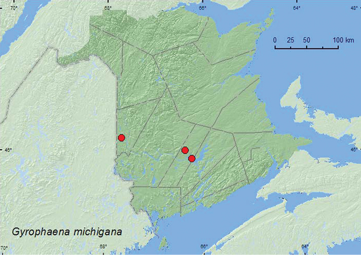
Collection localities in New Brunswick, Canada of Gyrophaena michigana.
In New Brunswick, this species was collected from fresh gilled mushrooms in a mixed forest, a silver maple swamp, and a mature red spruce and red maple forest. Adults were collected during June, July, and August. Little was previously known about the habitat associations and bionomics of this species.
NB (new Canadian record).
http://species-id.net/wiki/Gyrophaena_uteana
Map 14; Figs 116c, d inNew Brunswick , Carleton Co., (Belleville) Meduxnekeag Valley Nature Preserve, 46.1957°N, 67.6803°W, 1.VIII.2004, R. P. Webster, mixed forest, on bracket fungi (1 ♂, LFC 1 ♀, RWC); same locality and collector but 46.1907°N, 67.6740°W, 23.VI.2006, mixed forest, on gilled mushroom (1 ♂, RWC); same locality data and collector but 19.VII.2006, mixed forest, on small gilled mushrooms on log (Photo 2008-93, ♂, RWC); same locality data and collector but 7.IX.2004, mixed forest, on fleshy (gilled) fungi (Photo 2008-107, 1 ♀, LFC); same locality and collector but 46.1940°N, 67.6800°W, 3.VII.2006, mixed forest, in Pleurotus sp. on dead standing Populus tremuloides (Photo 2008-106, 1 ♂, LFC; 1 ♂, RWC); same locality and collector but 46.1910°N, 67.6740°W, 31.VIII.2006, mixed forest, on polypore fungi (1 ♂, LFC; 1 ♂, RWC). York Co., Keswick River at Rt. 105, 45.9920°N, 66.8334°W, 9.VII.2009, R. P. Webster, silver maple swamp, on small gilled mushrooms on log (2 ♂, RWC).

Collection localities in New Brunswick, Canada of Gyrophaena uteana.
Gyrophaena uteana from New Brunswick was collected in mixed forests and a silver maple swamp. Adults were collected from polypore fungi, on fresh gilled mushrooms, on a small (fresh) gilled mushroom on a log, and from a Pleurotus sp. on a dead, standing trembling aspen (Populus tremuloides Michx.). Adults were collected during June, July, August, and September.
BC, QC, NB (
http://species-id.net/wiki/Gyrophaena_wisconsinica
Map 15; illustrationsCanada, New Brunswick, Restigouche Co., Jacquet River Gorge P. N. A., 47.8201°N, 65.9992°W, 12.VIII.2010, R. P. Webster, black spruce/balsam fir/cedar forest near Belledune Bog, in gilled mushroom (1 ♂, RWC).
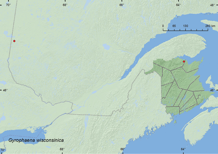
Collection localities in New Brunswick and Quebec, Canada of Gyrophaena wisconsinica.
Quebec, Abitibi, lac Duparquet, (48.46926°N, 79.27164°W) 22.VIII.1997, Berlese, Éc. peup. mort + champ Échant. S-101 1944, Peupleraie, P. Paquin (20 ♂, 32 ♀ females, LFC).
One individual of this species from New Brunswick was collected during August from a fresh gilled mushroom in a black spruce, balsam fir, and eastern white cedar forest. Specimens from Quebec were collected by Berlese extaction of dead poplar bark and mushrooms from a poplar forest. Samples were collected during late August.
QC, NB. (new Canadian record)
http://species-id.net/wiki/Leptusa_gatineauensis
Map 16; illustrations inNew Brunswick, Carleton Co., Jackson Falls, “Bell Forest”, 46.2200°N, 67.7230°W, 20-26.V.2009, R. Webster & M.-A. Giguère, rich Appalachian hardwood forest, Lindgren funnel trap (1 ♂, RWC). Queens Co., Cranberry Lake P.N.A., 46.1125°N, 65.6075°W, 13-25.V.2011, 25.V–7.VI.2011, M. Roy & V. Webster, old red oak forest, Lindgren funnel traps (3 ♂, RWC). Sunbury Co., Acadia Research Forest, 45.9866°N, 66.3841°W, 9-16.VI.2009, M.-A. Giguère & R. Webster mature (110-year-old) red spruce forest with scattered red maple and balsam fir, Lindgren funnel trap (1 ♀, RWC). York Co., 15 km W of Tracy, off Rt. 645, 45.6848°N, 66.8821°W, 10-26.V.2010, 4–16.VI.2010, R. Webster & C. MacKay, coll., old red pine forest, Lindgren funnel traps (1 ♂, 2 ♀, LFC, RWC); 16 km W of Tracy, off Rt. 645, 45.6855°N, 66.8847°W, 18.V-2.VI.2010, R. Webster & C. MacKay, coll., old red pine forest, Lindgren funnel trap (1 ♂, RWC).

Collection localities in New Brunswick, Canada of Leptusa gatineauensis.
The specimens from New Brunswick were captured in Lindgren funnel traps deployed in an old red pine forest, a mature (110-year-old) red spruce forest, an old red oak forest, and a rich Appalachian hardwood forest. Elsewhere, adults were captured in deciduous and mature red spruce–hemlock forests; some specimens were captured on Polyporus betulinus (Bull.) Fries) (
BC, ON, QC, NB, NS, NL (
http://species-id.net/wiki/Leptusa_canonica
Map 17; illustrationsNew Brunswick, Charlotte Co., 10 km NW of New River Beach, 45.2110°N, 66.6170°W, 10-23.VIII.2010, R. Webster and C. MacKay, old growth eastern white cedar forest, Lindgren funnel trap (1 sex undetermined, AFC). Queens Co., Cranberry Lake P.N.A., 46.1125°N, 65.6075°W, 28.VI–1.VII.2009, 15-21.VII.2009, 21-28.VII.2009, 14–19.VIII.2009, 19.VIII-2.IX.2009, R. Webster and M.-A. Giguère, red oak forest, Lindgren funnel traps (5 ♂, 5 ♀, RWC). York Co., 15 km W of Tracy off Rt. 645, 45.6848°N, 66.8821°W, 14–20.VII.2009, 20-29.VII.2009, R. Webster and M.-A. Giguère, old red pine forest, Lindgren funnel trap (1 sex undetermined, AFC); 14 km WSW of Tracy, S of Rt. 645, 45.6741°N, 66.8661°W, 16–30.VI.2010, R. Webster and C. MacKay, old mixed forest with red and white spruce, red and white pine, balsam fir, eastern white cedar, red maple, and Populus sp., Lindgren funnel trap (1 ♂, AFC).

Collection localities in New Brunswick, Canada of Leptusa canonica.
ON, QC, NB, NS, NF (
http://species-id.net/wiki/Silusa_langori
Map 18; illustrationsNew Brunswick, Restigouche, Co., Dionne Brook P.N.A, 47.9064°N, 68.3441°W, 27.VI–14.VII.2011, M. Roy & V. Webster, old-growth white spruce and balsam fir forest, Lindgren funnel trap (1 ♂, RWC). York Co., 15 km W of Tracy off Rt. 645, 45.6848°N, 66.8821°W, 19–25.V.2009, R. Webster and M.-A. Giguère, old red pine forest, Lindgren funnel trap (1 ♂, RWC); same locality data and forest type, 10–26.V.2010, R. Webster & C. MacKay, Lindgren funnel trap (1 ♂, RWC); Charters Settlement, 45.8395°N, 66.7391°W, 4.IV.2010, R. P. Webster, mixed forest opening, collected with aerial net during evening flight between 16:30 and 19:00 h (1 ♂, RWC).
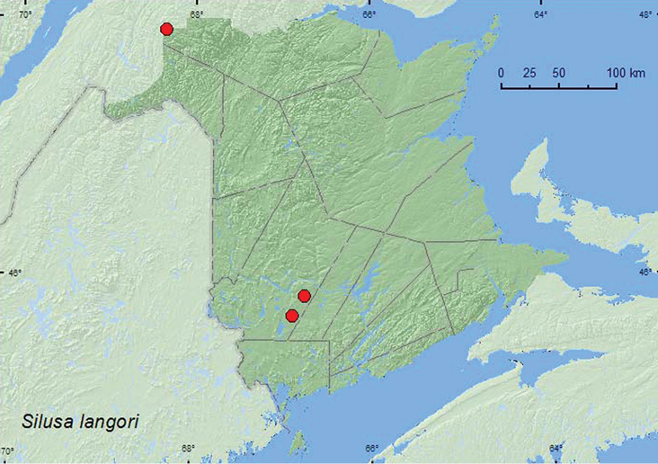
Collection localities in New Brunswick, Canada of Silusa langori.
In New Brunswick, adults of this species were collected during April, May, June, and July in Lindgren funnel traps deployed in an old red pine forest, an old-growth white spruce and balsam fir forest, and with an aerial net during an evening flight within a mixed forest opening. In Alberta, adults were captured in pitfall traps and window traps in boreal mixed woods comprising 54–83% Populus sp.(
AB, NB (
http://species-id.net/wiki/Acrotona_smithi
Map 19; illustrations inNew Brunswick, Saint John Co., Dipper Harbour, 45.1169°N, 66.3771°W, 7.V.2006, 15.V.2006, 30.V.2006, R. P. Webster, upper margin sea beach, in decaying sea wrack and debris under alders (2 ♂, 1 ♀, 1 sex undetermined, LFC; 3 ♂, 4 ♀, 1 sex undetermined, RWC); same locality and collector but 45.1154°N, 66.3720°W, 12.V.2008, sea beach, in decaying sea wrack on gravel and sand (1 ♂, 1 ♀, 1 sex undetermined, RWC.
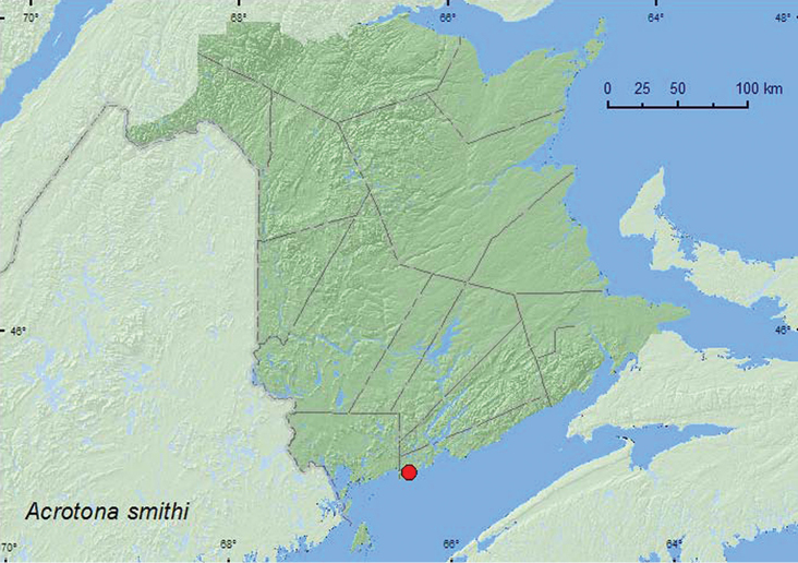
Collection localities in New Brunswick, Canada of Acrotona smithi.
Specimens of Acrotona smithi Casey from New Brunswick were collected during May on the upper margin of a sea beach from decaying sea wrack under alders (Alnus sp.) and on gravel and sand.
NB. This species is more widely distributed in eastern Canada, and all other new records are reported in
http://species-id.net/wikiAcrotona_sequestralis
Map 20; illustrations inNew Brunswick, Restigouuche Co., Jacquet River Gorge P.N.A., 47.7361°N, 66.0778°W, 16.VIII.2010, R. P. Webster, coll., beaver dam, among sticks and debris near an overflow area of dam (near flowing water) (1 ♂, RWC).

Collection localities in New Brunswick, Canada of Acrotona sequestralis.
Specimens of Acrotona sequestralis (Casey) from New Brunswick were collected in August from debris near an overflow area of a beaver dam.
NL, NB (
http://species-id.net/wiki/Atheta_circulicollis
Map 21; illustrationsNew Brunswick, Carleton Co., Belleville, Meduxnekeag Valley Nature Preserve, 46.1910°N, 67.6740°W, 13.VIII.2006, R. P. Webster, mixed forest, on Pleurotus sp. on side of log (1 ♂, RWC).
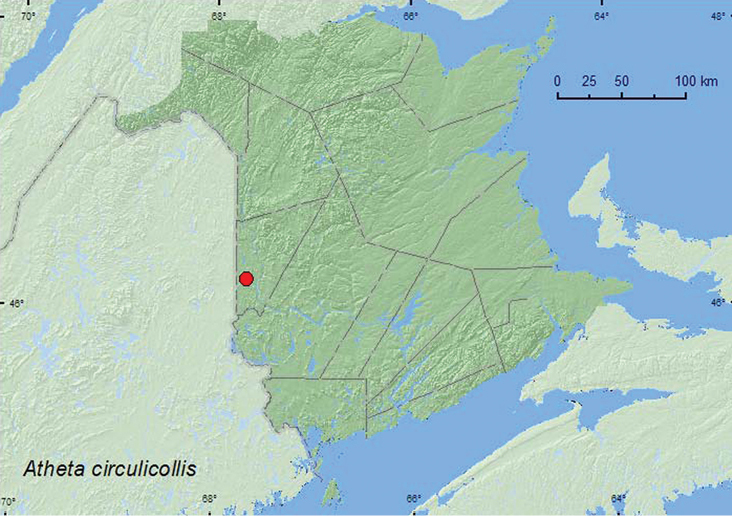
Collection localities in New Brunswick, Canada of Atheta circulicollis.
The only specimen of this species from New Brunswick was collected during August from a Pleurotus sp. on the side of a log. Specimens from NF & LB were captured in pitfall traps deployed in fir forests, riparian forests, and a recently burned coniferous forest (
QC, NB, NF, LB (
http://species-id.net/wiki/Atheta_pseudomodesta
Map 22; illustrationsNew Brunswick, Restigouche Co. Jacquet River Gorge P.N.A., 47.8207°N, 65.9955°W, 15.VI.2009, R.P. Webster, black spruce forest with Populus sp., on gilled mushroom (1 ♂, 1 ♀, NBM, RWC); same locality and collector but 47.8201°N, 65.9992°W, 12.VIII.2010, black spruce/balsam fir/cedar forest near Belledune Bog, in gilled mushroom (1 ♂, NBM); Dionne Brook P.N.A., 47.9030°N, 68.3503°W, 30.V–15.VI.2011, M. Roy & V. Webster, old-growth northern hardwood forest, Lindgren funnel trap (1, RWC).

Collection localities in New Brunswick, Canada of Atheta pseudomodesta.
ON, QC, NB, NS, NL (
http://species-id.net/wiki/Atheta_terranovae
Map 23; illustrations inNew Brunswick, Carleton Co., Belleville, Meduxnekeag Valley Nature Preserve, 46.1927°N, 67.6803°W, 4.V.2006, R. P. Webster, 16.IX.2006, R. P. Webster, coll., mixed forest in decaying gilled mushrooms (1 ♂, RWC; 1 ♂, LFC); same locality and collector except, 46.1907°N, 67.6740°W, 14.IX.2005, mixed forest on gilled fungi (1 ♂, 1 ♀, RWC; 1 ♂, LFC); same locality data and collector, 7.IX.2004, mixed forest on rotting fungi (1 ♀, RWC). Charlotte Co., near New River, 45.2122°N, 66.6160°W, 22.IX.2006, R. P. Webster, coll., eastern white cedar swamp, in gilled mushroom (1 ♂, RWC). Queens Co., Cranberry Lake P.N.A., 46.1125°N, 65.6075°W, 22.IX.2009, R. P. Webster, coll., red oak forest, in decaying gilled mushrooms (1 ♂, RWC ). Restigouche Co., Jacquet River Gorge P.N.A., 47.8201°N, 65.9992°W, 12.VIII.2010, R. P. Webster, coll., black spruce forest, in gilled mushrooms (1 ♀, NBM); same locality and collector but 47.8254°N, 66.0780°W, 18.VIII.2010, spruce /fir forest, in decaying lobster mushrooms (1 ♂, RWC ). Saint John Co., Chance Harbour (off Rt. 790), 45.1391°N, 66.3696°W, 24.VIII.2006, R. P. Webster, coll., red spruce & birch forest, in gilled mushrooms (1 ♂, 1 ♀, RWC); same locality data and collector, 16.IX.2008, mixed forest, in decaying gilled mushrooms (1 ♂, NBM); Dipper Harbour, 45.1176°N, 66.3806°W, 12.IX.2006, R. P. Webster, coll., red spruce forest, on gilled mushrooms (1 ♀, RWC). Sunbury Co., Acadia Research Forest, 46.0188°N, 66.3765°W, 18.IX.2007, R. P. Webster, coll., Road 16 control, mature red spruce & red maple forest, in coral fungi on spruce log (1 ♂, 1 ♀, RWC); same locality and collector but 45.9799°N, 66.3394°W, 18.IX.2007, Road 7 control, mature red spruce & red maple forest, in gilled mushrooms (1 ♂, RWC). York Co., Charters Settlement, 45.8286°N, 66.7365°W, 6.IX.2005, 4.X.2005, R. P. Webster, coll., mature red spruce & cedar forest, in decaying mushrooms (3 ♀, RWC).
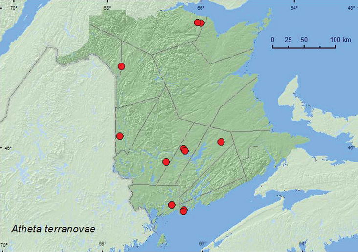
Collection localities in New Brunswick, Canada of Atheta terranovae.
NB, NL, QC (
http://species-id.net/wiki/Atheta_pseudosubtilis
Map 24; illustrations inNew Brunswick, Carleton Co., Belleville, Meduxnekeag Valley Nature Preserve, 46.1910°N, 67.6740°W, 4.V.2006, R. P. Webster, balsam fir stand, in moldy conifer duff at base of white pine, (4 ♂, 2 ♀, RWC; 1 ♂, LFC); same locality data and collector except 46.1907°N, 67.6740°W, 11.V.2005, balsam fir stand, in moldy conifer duff (2 ♀, RWC). York Co., Charters Settlement, 45.8395°N, 66.7391°W, 22.IV.2004, R. P. Webster, coll., mixed forest, in leaf litter & moss near small shaded stream (1 ♀, RWC).

Collection localities in New Brunswick, Canada of Atheta pseudosubtilis.
Specimens from New Brunswick were collected from moldy conifer duff at the base of a white pine in a balsam fir stand during May and from leaf litter and moss near a small, shaded stream in a mixed forest during April. The Newfoundland specimens were captured from June through August in mixed wood and coniferous forests, using unbaited and carrion-baited pitfall and intercept traps (
NB, NL (
http://species-id.net/wiki/Clusiota_impressicollis
Map 25; illustrations inNew Brunswick, Restigouche Co., Dionne Brook P.N.A., 47.9064°N, 68.3441°W, R. P. Webster, 9.VIII.2011, under coyote dung on gravel road (1 ♂, RWC).

Collection localities in New Brunswick, Canada of Clusiota impressicollis
The specimen from New Brunswick was collected from under coyote (Canis latrans Say) dung on a gravel road during August. Specimens from Newfoundland were collected in flight intercept traps deployed in a fir–decidous forest during July–August. Otherwise little is known about the habitat requirements and biology of this species.
BC, ON, NB, NL (
http://species-id.net/wiki/Hydrosmecta_pseudodiosica
Map 26; illustrations inNew Brunswick, Restigouche Co., Jacquet River Gorge P.N.A., 47.8257°N, 66.0779°W, 14.V.2010, R. P. Webster, coll., partially shaded cobblestone bar near outflow of brook at the Jacquet River, under cobblestones and gravel on sand (3 ♂, 1 ♀, RWC; 1 ♂, LFC); same locality and habitat data and collector except 24.V.2010 (4 ♂, 3 ♀, RWC); same locality and collector but 47.8257°N, 66.0768°W, 16.VI.2009, balsam poplar forest, medium sized stream near outflow into Jacquet River, on partially shaded cobblestone island, among cobblestones (2 ♀, RWC).

Collection localities in New Brunswick, Canada of Hydrosmecta pseudodiosica.
The specimens from New Brunswick were collected from under small cobblestones and gravel set in sand on a partially shaded cobblestone bar near the outflow of a brook into a clear rocky river. Adults were collected during May and June.
YT, ON, NB, (
http://species-id.net/wiki/Hydrosmecta_newfoundlandica
Map 27; illustrations inNew Brunswick, Albert Co., Caledonia Gorge P.N.A., at Crooked Creek, 45.7930°N, 64.7764°W, 1.VII.2011, R. P. Webster, small clear cold rocky river, among cobblestones on river margin (1 ♂, NBM). Carleton Co., Belleville, Meduxnekeag Valley Nature Preserve, 46.1897°N, 67.6751°W, 19.VII.2009, R. P. Webster, rich Appalachian hardwood forest, margin of spring-fed brook among gravel on firm sand/clay/gravel mix (1 ♂, RWC). Restigouuche Co., Jacquet River Gorge P.N.A., 47.8257°N, 66.0768°W, 16.VI.2009, 14.V.2010, R. P. Webster, coll., balsam poplar forest, medium sized stream near outflow into Jacquet River, on partially shaded cobblestone island among cobblestones, (4 ♂, 3 ♀, 1 sex undetermined, RWC, LFC). York Co., 1.5 km N of Durham Bridge, 46.1408°N, 66.6179°W, 15.VI.2008, R. P. Webster, coll., Nashwaak River at river margin among cobblestones near outflow of a brook, (7 ♂, 4 ♀, RWC, LFC).

Collection localities in New Brunswick, Canada of Hydrosmecta newfoundlandica.
Most specimens from New Brunswick were collected from among cobblestones along clear, rocky river margins near the outflow of brooks. One individual was collected from the margin of a spring-fed brook among gravel on firm sand/clay/gravel mix near the outflow of the brook into a clear, rocky river. Specimens were usually found among cobblestones at waters edge. Adults were collected during May, June, and July. Adults from Newfoundland were captured from an unknown habitat in July and August (
NB, NL (
http://species-id.net/wiki/Tomoglossa_decora
Fig. 5, Map 28; illustrations inCanada, New Brunswick, Charlotte Co., near Little Lepreau, 45.1242°N, 66.4732°W, 11.VII.2008, R. P. Webster, coll., barrier beach, intertidal zone, under small rocks in sand/clay mix near small bay, 1 to 2 meters below mean high tide mark (2 ♂, RWC ). Saint John Co., Chance Harbour off Cranberry Head Rd., 45.1350°N, 66.3439°W, 6.VII.2008, R. P. Webster coll., barrier beach, intertidal zone, under cobble stones in sand adjacent to salt marsh, about 0.5 meters below mean high tide mark, (2 ♀, RWC); same locality and collector except 45.1357°N, 66.3451°W, 11.VII.2008, under cobble stones in sand adjacent to salt marsh, about 0.5-2.0 meters below mean high tide mark (1 ♂, LFC; 1 ♀, RWC ); same locality and collector but 45.1354°N, 66.3438°W, salt marsh, under small rock on salt marsh side of barrier beach (1 ♂, RWC ); Chance Harbour, 45.1173°N, 66.3766°W, 25.VI.2010, R. P. Webster, salt marsh adjacent to barrier beach, under small rock among Spartina patens (1 ♀, RWC).

Collection localities in New Brunswick, Canada of Tomoglossa decora.
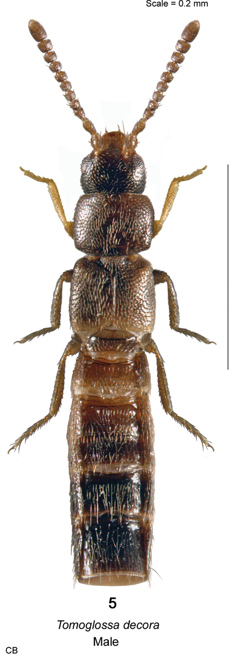
Tomoglossa decora (Casey) habitus in dorsal view.
In New Brunswick, this species was found on the salt marsh side of barrier beaches in the intertidal zone, 1–2 m below the mean high-tide mark. Adults occurred under small rocks set in sand or a sand–clay mix in areas with sparse Spartina patens (Ait.) Muhl. (salt meadow grass). Adults were collected during June and July.
NB (new Canadian record).
http://species-id.net/wiki/Liogluta_aloconotoides
Map 29: illustrations inNew Brunswick, Albert Co., Shepody N.W.A., Mary’s Point Section, 45.7320°N, 64.6765°W, 12.IX.2004, R. P. Webster, spruce forest, in dung (1 ♀, RWC). Carleton Co., Jackson Falls, “Bell Forest”, 46.2200°N, 67.7231°W, 12-19.VII.2008, R. P. Webster, rich Appalachian hardwood forest with some conifers, Lindgren funnel trap (1 ♂, RWC). Kings Co., Sussex, 3.VIII.1994 (J. Sweeney), pitfall control 3-3 (1 ♀, AFC). Madawaska Co., Loon Lake, 236 m elev., 47.7839°N, 68.3843°W, 21.VII.2010, R. P. Webster, boreal forest, small lake surrounded by sedges, treading sedges near Myrica gale bushes (1 ♂, 1 ♀, RWC).

Collection localities in New Brunswick, Canada of Liogluta aloconotoides.
YT, ON, QC, NB, NS, LB, NF (
http://species-id.net/wiki/Lypoglossa_angularis_obtusa
Map 30; illustrations inNew Brunswick, Restigouche Co., MacFarlane Brook Protected (Natural) Area, 47.6018°N, 67.6263°W, 25.V.2007, R. P. Webster, old growth eastern white cedar swamp, in moss and leaves under alders near brook (1 ♀, RWC); Mount Atkinson, 447 m elev., 47.8192°N, 68.2618°W, 24.VIII.2011, R. P. Webster, spruce and balsam fir forest, small, shaded, spring-fed brook with mossy margin, in wet moss (1 sex undetermined, RWC).
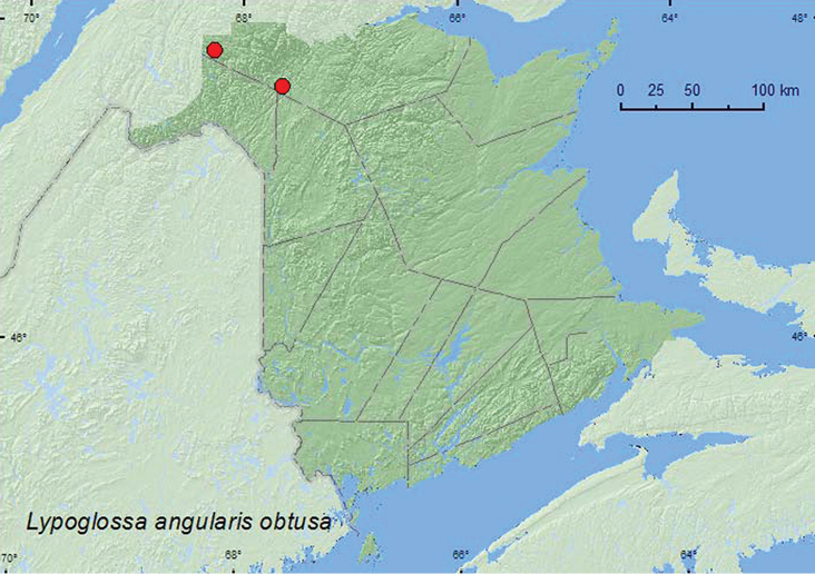
Collection localities in New Brunswick, Canada of Lypoglossa angularis obtusa.
In Newfoundland, this species has been captured in unbaited and carrion-baited pitfall traps in old balsam fir, spruce and balsam fir, birch and riparian forests and shrubby coastal barrens (
QC, NB, NS, LB, NF (
http://species-id.net/wiki/Philhygra_jarmilae
Map 31; illustrationsNew Brunswick, Carleton Co., (Belleville) Meduxnekeag Valley Nature Preserve, 46.1976°N, 67.6850°W, 4.V.2006, R. P. Webster, mixed forest, margin of vernal pond, in moist leaf litter (1 ♀, RWC); 1.3 km E jct. Rt. 540 & Plymouth Rd., 46.1867°N, 67.6817°W, 7.V.2008, R. P. Webster, rich Appalachian hardwood forest, in moss & leaf litter in seepage area (1 ♀, RWC); Jackson Falls, 46.2257°N, 67.7437°W, 12.IX.2009, R. P. Webster, river margin near waterfall, splashing moss near splash zone of waterfall (1 ♂, RWC). Queens Co., W of Jemseg near “Trout Creek”, 45.8255°N, 66.1174°W, 1.VII.2008, R. P. Webster, seasonally flooded marsh, treading vegetation near margin of pool (1 ♂, 1 ♀, RWC); Canning, Grand Lake near Scotchtown, 45.8762°N, 66.1817°W, 25.V.2006, R. P. Webster, silver maple swamp near lake margin, margin of vernal pond, in moist leaves (3 ♂, 1 ♀, NBM, RWC). Restigouche Co., Little Tobique R. near Red Brook, 47.4465°N, 67.0689°W, 13.VI.2006, R. P. Webster, alder swamp near river, in debris on muddy soil near brook (1 ♂, RWC); Jacquet River Gorge P.N.A., 47.7627°N, 66.0270°W, 24.VI.2008, R. P. Webster, hardwood forest, margin of vernal pool, among moist leaves (1 ♀, RWC); same locality and collector but 47.7357°N, 66.0774°W, 24.VI.2008, among leaves and sedges near pond margin (1 ♂, RWC); same locality and collector but 47.8257°N, 66.0768°W, 16.VI.2009, balsam poplar forest, medium sized stream near outflow into Jacquet River, on partially shaded cobblestone island, among cobblestones (1 ♂, NBM); same locality and collector but 47.8200°N, 66.0015°W, 13.V.2010, under alders in leaf litter & moss near small brook in Carex marsh (1 ♂, NBM); Wild Goose Lake, 420 m elev., 47.8540°N, 68.3219°W, 7.VI.2011, R. P. Webster & M. Turgeon, lake margin with emergent Carex & grasses, treading Carex & grasses (1 ♂, NBM). York Co., Fredericton, at St. John River, 45.9588°N, 66.6254°W, 4.VII.2004, R. P. Webster, margin of river, in drift material (mostly maple seeds) (1 ♂, NBM); Charters Settlement, 45.8340°N, 66.7450°W, 29.V.2008, R. P. Webster, mature mixed forest, margin of vernal pond, among moist leaves (1 ♂, RWC).

Collection localities in New Brunswick, Canada of Philhygra jarmilae.
In New Brunswick, Philhygra jarmilae was found in various wetland habitats. Adults were sifted from moist leaves along the margin of vernal ponds in mixed forests, a hardwood forest, and a silver maple swamp, sifted from leaves and sedges along a pond margin, treaded from Carex and grasses along a lake margin, sifted from moss and leaf litter in a seepage area in a hardwood forest, treaded from vegetation in a seasonally flooded marsh near a pool, sifted from debris on muddy soil near a brook, sifted from leaf litter and moss under alders near a brook, and from drift material on a river margin, hand collected from cobblestones on a partially shaded cobblestone bar along a medium-sized stream, and collected by splashing water on moss near the splash zone of a waterfall. Adults were captured during May, June, July, and September in New Brunswick. The holotype was captured in a flight intercept trap in a mixed forest (
NB, NF (
http://species-id.net/wiki/Philhygra_luridipennis
Map 32; illustrationsNew Brunswick, Carleton Co. Jackson Falls, 46.2257°N, 67.7437°W, 12.IX.2009, R. P. Webster, river margin near waterfall, splashing moss near splash zone of waterfall (1 ♀, RWC). Madawaska Co., Gagné Brook at First Lake, 47.6077°N, 68.2534°W, 23.VI.2010, M. Turgeon & R. Webster, northern hardwood forest, shaded brook among gravel on gravel bar, splashing, turning gravel (1 ♂, RWC). Restigouche Co., Little Tobique R. near Red Brook, 47.4465°N, 67.0689°W, 13.VI.2006, R. P. Webster, alder swamp near river, in debris on muddy soil near brook (1 ♀, RWC); Jacquet River Gorge P.N.A., 47.8257°N, 66.0768°W, 16.VI.2009, R. P. Webster, mixed mature forest, cool clear medium sized stream, in gravel & under cobble stones near margin of stream (1 ♂, 1 ♀, RWC); 1.5 km S of Quebec (border), 425 m elev., 47.9058°N, 68.1505°W, 22.VI.2010, R. P. Webster, boreal forest, small shaded brook, splashing gravel on gravel bar (1 ♂, RWC); Kedgwick Forks, 47.9085°N, 67.9057°W, 22.VI.2010, R. P. Webster, river margin on clay/sand, under alders (1 ♀, RWC). York Co., Charters Settlement, 45.8395°N, 66.7391°W, 26.VII.2005, R. P. Webster, mixed forest, M.V. light (1 ♀, RWC); same locality data and collector, 21.IV.2010, mixed forest opening, collected with aerial net during evening flight between 16:30 and 19:00 h (1 ♂, RWC).

Collection localities in New Brunswick, Canada of Philhygra luridipennis.
Most adults of Philhygra luridipennis from New Brunswick were collected from riparian habitats in various deciduous and coniferous forest types. Specimens were collected from gravel (splashing and turning gravel) on gravel bars along shaded brooks in a northern hardwood forest and a boreal forest with balsam fir and white spruce, hand collected from gravel and from under cobblestones on the margin of a clear, medium-sized stream in a mixed forest, sifted from debris on muddy soil near a brook in an alder swamp, hand collected from a sand and clay mix under alders near a river margin, and collected by splashing water on moss near the splash zone of a waterfall. Other specimens were collected at a mercury vapor light and with an aerial net during an evening flight near a mixed forest and nearby stream. Adults were collected during April, June, July, and September. Little was previously known about the habitat associations of this species. The male specimen from Newfoundland was captured in a flight intercept trap in a mixed forest (
NB, NF (
http://species-id.net/wiki/Philhygra_sinuipennis
Map 33; illustrationsNew Brunswick, York Co.8.5 km W of Tracy off Rt. 645, 45.6821°N, 66.7894°W, 8.V.2008, R. P. Webster, alder swamp, in moist litter & grass on hummocks near water (9 ♂, 1 ♀, RWC).

Collection localities in New Brunswick, Canada of Philhygra sinuipennis.
The holotype of Philhygra sinuipennis from Newfoundland was collected from among litter and stones on a sandy lakeshore (
NB, NF (
http://species-id.net/wiki/Philhygra_varula
Map 34; illustrations inNew Brunswick, Albert Co., Shepody N.W.A., Mary’s Point Section, 45.7321°N, 64.6765°W, 17.V.2004, R. P. Webster, freshwater marsh adjacent to salt marsh, under litter on drift wood (large log) (2 ♀, RWC). Saint John Co. Dipper Harbour, 45.1169°N, 66.3771°W, 15.V.2006, R. P. Webster, upper margin sea beach, in decaying sea wrack under alders (2 ♀, RWC); same locality and collector but 45.1182°N, 66.3790°W, 28.V.2010, R. P. Webster, upper margin of salt marsh, in grass litter in seepage area with Carex and Spartina patens (3 ♂, 3 ♀, RWC).
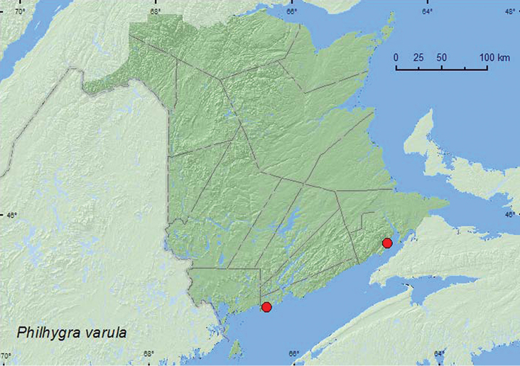
Collection localities in New Brunswick, Canada of Philhygra varula.
This species has been reported from under lakeshore debris and in rotting mushrooms in Newfoundland (
QC, NB, LB, NF (
http://species-id.net/wiki/Boreophila_eremita
Map 35; illustrations inNew Brunswick, Queens Co., W of Jemseg near “Trout Creek”, 45.8255°N, 66.1174°W, 1.VII.2008, R. P. Webster, seasonally flooded marsh, treading vegetation near margin of pool (1 ♀, RWC). Restigouche Co., Jacquet River Gorge P.N.A., 47.8221°N, 66.0082°W, 13.V.2010, R. P. Webster, margin of Carex marsh, in leaf litter and grass litter under shrubs (1 ♀, NBM). Sunbury Co., near Sunpoke Lake, 45.7658°N, 66.5546°W, 3.VII.2008, R. P. Webster, red oak forest near flooded marsh, in leaf litter (1 ♂, RWC). York Co. Rt. 645 at Beaver Brook, 45.6860°N, 66.8668°W, 6.V.2008, R. P. Webster, Carex marsh, in (woody) litter at base of dead red maple (2 ♂, 3 ♀, RWC); Charters Settlement, 45.8395°N, 66.7391°W, 6.V.2008, R. P. Webster, mixed forest, in flight on warm 20°C afternoon (1 ♀, RWC).
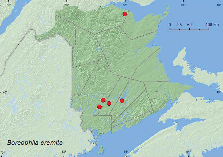
Collection localities in New Brunswick, Canada of Boreophila eremita.
Boreophila eremita was collected from various marsh habitats in New Brunswick. Adults were collected by treading vegetation in a seasonally flooded marsh, sifted from leaf litter and grass litter under alders in a Carex marsh, sifted from woody litter at the base of a dead red maple in a Carex marsh (probably an overwintering site), and sifted from leaf litter in a red oak marsh surrounded by a completely flooded marsh. One individual was collected with an aerial net during a warm (20°C) afternoon. Adults were captured during May and July in New Brunswick. No other habitat data are available from Canada and Alaska (
AK, YT, NB, NF (
http://species-id.net/wiki/Thamiaraea_brittoni
Map 36; illustrationsNew Brunswick, Queens Co., Cranberry Lake P.N.A., 46.1125°N, 65.6075°W, 25.VI-1.VII.2009, R. Webster and M.-A. Giguère coll., red oak forest, Lindgren funnel trap (1 ♂, RWC); same locality data and forest type, 12-26.VII.2010, R. Webster & C. MacKay, Lindgren funnel trap (1 ♂, RWC).

Collection localities in New Brunswick, Canada of Thamiaraea brittoni.
The two males were captured in a red oak forest during June and July using Lindgren funnel traps.
ON, QC, NB (
http://species-id.net/wiki/Cordalia_obscura
Map 37; illustration inNew Brunswick, York Co., Charters Settlement, 45.8395°N, 66.7391°W, 20.VI.2008, 9.IX.2009, 17.V.2010, 18.IX.2010, R. P. Webster, mixed forest, in decaying (moldy) corncobs and cornhusks (1 ♀, 3 sex undetermined, RWC).

Collection localities in New Brunswick, Canada of Cordalia obscura.
ON, QC, NB (
http://species-id.net/wiki/Falagria_sulcata
Map 38; illustrations inNew Brunswick, York Co., Charters Settlement, 45.8395°N, 66.7391°W, 16.X.2004, R. P. Webster, mixed forest, in compost (decaying vegetables) (2 sex undetermined, RWC).

Collection localities in New Brunswick, Canada of Falagria sulcata.
In North America, this adventive species was reported from a haystack by
AB, ON, QC, NB (
We thank Caroline Simpson for editing this manuscript and Adam Brunke is thanked for reviewing this manuscript. Nichole Brawn, Katie Burgess, Stephen Clayden, Marie-Andrée Giguère, Nancy Harn, Cory Hughes, Rob Johns, Ervin Kovacs, Marsella Laity, Colin MacKay, Wayne MacKay, F. Roy, Michelle Roy, Jessica Price, Martin Turgeon, and Vincent Webster are thanked for technical assistance and collecting specimens. Martin Turgeon is thanked for assistance with locating sites in the boreal forest areas of north western New Brunswick. We thank Natural Resources Canada, Canadian Forest Service, the Canadian Food Inspection Agency, and the USDA APHIS for funding the study on early detection of invasive Cerambycidae, which provided specimens from Lindgren funnel traps. The Canadian Wildlife Service is thanked for funding insect surveys at the Portobello Creek National Wildlife Area, the New Brunswick Environmental Trust Fund and New Brunswick Wildlife Trust Fund for funding various insect surveys over the past 7 years, and the Meduxnekeag River Association for permission to sample beetles at the Meduxnekeag Valley Nature Preserve (which includes the Bell Forest). Biological survey work in the Jacquet River Gorge and Caledonia Gorge Protected Natural Areas was organized through the New Brunswick Museum, with external funding from the New Brunswick Environmental Trust Fund, Salamander Foundation, and the New Brunswick Wildlife Trust Fund. The New Brunswick Department of Natural Resources (Fish and Wildlife Branch) is thanked for issuing permits for sampling in the Protected Natural Areas and for providing logistical support. The images were provided by C. Bourdon (LFC) and J. Dorval (LFC).